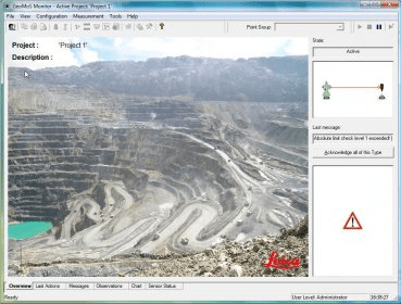
Leica GeoMoS is a multi-purpose automatic deformation monitoring software that can be used for:
- Structural deformation monitoring (e.g. dams, tunnels, bridges, high-rise buildings, construction)
- Landslide and settlement detection (e.g. mining, rock falls, volcano slopes, subsidence)
- Automated surveys (e.g. continuous, automated measurements)
- And many more...

An easy-to-use program that allows you to convert any web page content to PDF.


Comments